Porcupyn's Blog

July 31, 2018

South Africa Trip – Day Seven (in Hermanus and Drive to Knysna)

Filed under: Family,Travel — Porcupyn @ 2:57 pm

The next morning, we woke up leisurely and got ready. The plan was to leave by ten am. But before that, we decided to walk to a whale viewing point (given that we wouldn’t be there for a long time, we didn’t have any realistic hopes of catching any whales in action, rather we just wanted to take in the sights). So, without much ado, let me share some photos of our walk to the shore or, more specifically, to Gearings Point.


Some astronomy related artifacts by the shoreline 🙂

Needless to say, though we spent about half an hour there at Gearings Point, we did not see any whales. So, we walked back towards the Airbnb to get ready for the next leg of the trip – a drive to Knysna on the Garden Route with a detour to Cape Agulhas.

But before we got back to the Airbnb, we stopped by a local store to get some groceries, mainly bread and butter and jam and some desserts. I took the opportunity to go around and take some photos at random. Though there is no story associated with these photos, but when you look at them, the colours are really nice to look at. And of course, folks who have never been there will get an idea of how much food costs in Hermanus (not much different from the rest of South Africa).

Of all the things we purchased in South Africa, my favourite dessert was the Malva Pudding from Woolworths. To be honest, the reason I first purchased it was because I misread the title which was similar to an Indian dessert. But once we baked it and started eating it, I was the only one in the family who could handle the richness and sweet taste. It proved too much for the rest of the family, so I ended up polishing it off all by myself (in multiple sittings, of course)! So, if you want one dessert recommendation for your South African trip, this is it!


My favourite dessert

I had read of some disturbances – cops vs locals – along our route to Knysna. As a result, I was a bit apprehensive as to whether we ought to change our planned route. No worries, said our host. She said that we shouldn’t really be having any issues. Such skirmishes are pretty normal and shouldn’t really impact the main roads. So, off we went.


Entrance to the town of Gaansbaai (Mrs. Porcupyn figured out that Baai is probably the equivalent of Bay) – there were many other “Baai”s along – or just off – the Garden Route


Just like the iconic Hollywood sign


A library in Gaansbaai where we stopped to ask questions about where whales can be seen from in the area (the whole area is referred to as the whale watching coast or something like that)


One of the South African minibuses (I’ve been referring to them as minibuses, but I believe they have their own unique name, which I don’t recall right now)


Driving through Gaansbaai


Pizza for the road (as we were not planning any stops for lunch, Mrs. Porcupyn baked pizza – along with the Malva pudding – in the morning before we left


Elim is a quaint – and clean – little town along our route to Cape Agulhas


Neat houses lay on either sides of the street


We couldn’t really figure out what the roofing material consisted of – it appears to be a thatched roof, but it is well compacted


Another of those minibuses


As we passed a couple of the sleepy villages enroute, I took photos of the road signs, so I could add up our route using google maps once we got back home 🙂


Before 1 pm, we were in the little seaside town of Agulhas. Lots of construction work is ongoing. Many of the houses in the area appeared to have only recently been constructed, observed Mrs. Porcupyn. Once she said that, I observed carefully and noticed that the lawns appeared as though the grass had been only recently laid.


We soon got to the light house. Across from the lighthouse (I believe behind us in this photo) is a welcome centre where we spent some time looking at the exhibits. Next to the lighthouse were toilet facilities which we used as well.


Boardwalk along the seashore


On second thoughts, I miswrote my previous caption. This view of the lighthouse is from the seaside. The visitor centre is – in this photo – behind the lighthouse (and across on the other side of the parking lot)


The route to the Cape Agulhas point was very gravelly. There were signs saying that we would need to proceed at our own risk. Initially, I wanted to leave our car near the visitor centre and walk to the Cape point, but then decided to drive it over, though very slowly. This was some sort of a construction area, with a lot of workers and a couple of construction trucks. I didn’t figure out what exactly they were up to – whether the road was being paved or the area was being beautified. The workers barely understood English and, needless to say, I have no idea what language they spoke. Upon our return (or maybe it was a signboard right there, I forget), I did see some article where this area was supposed to have been reconstructed and made more touristy a few years ago – don’t know what happened.


PS: Wanted to add a couple of photos that described changes that were supposed to have already happened here by now.


Neat new houses in Cape Agulhas


This tree was all over the place when we were driving near Cape Agulhas – I nicknamed it the Ostrich Tree

Random points along our drive to Knysna along the garden route. It took us about an hour or so to get back on the Garden Route (N2) from Cape Agulhas and then we sped right on towards Knysna. If we hadn’t had accommodation reserved in Knysna, we would likely have stopped at George, as the scenery descending towards Knysna from George was really nice but – once again – it was past sunset and we could not really enjoy it a lot.


Looks much nicer than it did when I was driving there 🙂


Sorry these photos are out of order. This is the location where we rejoined N2 after the side route to Hermanus and Cape Agulhas


On the way from Cape Agulhas to N2


We stopped the car and stepped out (only Baab and I) to take a few photos


Did the same on N2 (maybe not too wise a move)


This also is between Cape Agulhas and N2. Coming from the USA, the lane markers appear reversed. Here, we have a yellow centre line and have to always keep it to our left while driving.


Stopped by the roadside to take a few photos<

PS: Most of the photos in this post and the previous couple of photos are also by Baab

The plan had been to check out a couple of touristy areas near George – a Map of Africa dug into the countryside by the Kaaimans River as well as the Kaaimans Bridge, which is a narrow bridge across the river (don't know if there is any other significance to it). As it turned out, by the time we drove by George it was already past seven pm (maybe eight pm as well), so there was no point in going anywhere. We didn't have any issues finding the Airbnb place, though we had to go to the store near by to get the key for the entrance as it was really late and the owners weren't on site. It was a really nice place very near to the Knysna River.

I was a bit disappointed that we had taken too much time getting ready in the morning and/or had underestimated the driving time. So we resolved to wake up early the next morning and back track to George which was nearly an hour behind us. The plan was to visit the sightseeing spots right after getting up, then come back to Knysna to shower, eat, etc before heading east to Port Elizabeth.

– walk to spot any whales
– get snacks from the pick and go store
– Malva pudding
– visit Cape Agulhas
– drive on the Garden Route
– reach Knysna

July 30, 2018

South Africa Trip – Day Six (in Cape Town and drive to Hermanus)

Filed under: Family,Travel — Porcupyn @ 9:02 am

The original plan for our last day in Cape Town was to hike the Lion’s Head area. However, our feet – specifically knees – were not in much better shape. So, we abandoned that plan. Instead, we decided that we would do a circular drive around and behind Table Mountain, then check out the famous and relatively posh V&A waterfront area. In the afternoon, we would drive to the airport and do the car switcharoo then head over to Hermanus.

We took it easy in the morning. Thankfully, our airbnb accommodation had a washer and dryer. and got that going. Our check out time was ten am, but we requested our hosts to let us stay until 11 and he agreed. At this point, we were wondering where the airbnb photos were taken that showed a little outdoor swimming pool. From wherever we had been inside the complex, we hadn’t seen it. More power to Baab who ventured out (within the gated area of course) and found out that there is a roof access area from the fifth floor or so. So, leaving Mrs. Porcupyn and Katya to shower and generally get ready, we (Baab and I were packed but for the clothes in the dryer) went over to the roof. And wow! That was a pretty area indeed. I was glad that he found this area though, needless to say, we wouldn’t have been able to take too much advantage of it the previous two days, but I could have come up here during the lunar eclipse instead of having to crane my neck from our accommodation balcony!

I took some photos of the surrounding area, including the trains that were going by way below. That was a really nice view. After a while, we went downstairs and got Mrs.Porcupyn and Katya to come up as well and we got some selfies. Then we left on our drive.


Cape Towners, can you confirm that the trail to the left of this photo is the Platteklip Gorge Trail?


Commuter trains, as seen from the rooftop


Lion’s Head to the left and Lion’s Butt to the right (in case someone wonders why it’s called Lion’s Head, this should give some perspective)


Maybe there is no segregation, but I didn’t see any white kids in the group in the playground (looks like a high school)


Other views from our accommodation

Here are a couple of photos that we took by the roadside as we drove around the Table Mountain area (south, west and north of it) to get to the Victoria and Albert Waterfront. This posh area is named after Queen Victoria and her son.


There were signs of water shortage in several areas though we didn’t really have an issue with water

We then visited the Jetty from where political prisoners were transported to Robben Island and their relatives came to visit them (if granted permission). There were many of these letters requesting permission to meet with their relatives that were quite poignant!

All the days we were in South Africa were sunny and relatively warm compared to the week or so before we were there. Here is another good example of how clear the skies were, in general:


V&A waterfront Ferris Wheel as seen from inside the old Robben Island Jetty/museum

Some articles on the struggles against Apartheid and the outcomes


About political prisoners


Information about the iMadiba project


One of the entrances to the V&A waterfront Mall


Minibuses – these are driven by maniacal drivers as I found out later that day (though fortunately, I was able to avoid any incidents … and so did everyone else)


One of the stores selling curios

By the time we were done with the V&A waterfront, it was nearly 2 pm (if I recall correctly). I would have preferred going directly to the airport to return the car, grab a bite either along the way or over there, and head right out to Hermanus in the second rental car.


Table Mountain, as seen from the V&A waterfront

However, rightfully so (in hindsight), family had other plans. They wanted to check out an Ethiopian restaurant for lunch. Now, those who know me well know that I am very resistant to change in cuisine. Being a vegetarian, the only cuisine I am very comfortable with is Indian. Next (in no specific order) come Mexican, Italian and some American. I had never tried Ethiopian before and didn’t want to do so in Cape Town, of all places. Besides, I was really queasy about parking in Cape Town and walking around town, even in broad daylight.

Majority prevailed. I followed Baab’s GPS directions to a street parking spot somewhere in the CBD area more or less. It was a metered parking spot and immediately, an attendant materialized from somewhere and handed me a receipt of parking and stuck another one on the dashboard. We had stuff in the trunk, in the back seat and on the front seat. I was distinctly uncomfortable leaving the car with so much stuff there, though the attendant assured us all was good. We started walking. Every other minute, I asked “are we there yet?” – finally, after what seemed like eternity to me but was really less than a km probably, we found ourselves at AddisinCape.

Once we had seated ourselves and checked out the tastefully decorated surroundings, used the restroom etc, the server came over and asked us if we were ready to order. When we explained that it was our first time in an Ethiopian restaurant and that we were vegetarians, he made it a point to explain how Ethiopian food worked. Funnily enough, except for the communal aspect of it, it is exactly how we would have been eating in South India 🙂

They would be serving different entrees depending on our choice, laid over a big circular plate with a – for lack of a better word – crepe bread (its closest cousin in India would be the Dosa). These would be in bowls which then would be upended directly onto the bread. They would also be supplying similar bread rolled up similar to – for lack of a better comparison (sorry folks!) – toilet paper is wrapped. We were expected to – just like in India – eat with our fingers/hands, tearing off a piece of bread and dipping it into one of the entrees we ordered. Among the four of us, we ordered six entrees I believe. The food was delicious and filling, to say the least. I am now on the lookout for my next Ethiopian day out 🙂

Last but not the least, when we walked back to our car, we found it safe and sound.

It was past 4 pm by the time we left Cape Town CBD, but not before I got this photo 🙂


Trivia question – anyone know who Christiaan Bernard might be?

I knew we would be caught up in rush hour traffic and, sure enough, we did! The minibuses were coming from all kinds of directions and going in all kinds of directions – they were changing lanes with or without indicators, whether or not there was space for them. Kinda like in the USA, I thought 😉


Go across two lanes of traffic? No problem, maan!

Somewhere among the guide books that I had read, there had been warnings about these minibuses and their drivers (though the warnings were for the Jo’burg and Soweto area). Thankfully, we managed to negotiate the traffic without any incidents. When we reached the airport for our rental car swap, the sun was almost about to go down.


Yesterday’s sunset was at the Chapman Peak Drive; today’s at a rental car lot 🙂

We had a bit of an issue renting the one-way rental car. Baab had all the information accessible from his iPhone (left behind at Table Mountain a couple of days ago), and I didn’t have all of the email exchanges he had had. All I had was the reservation number and the corresponding paperwork. However, when we got to the rental counter, the representative insisted on adding an additional ZAR 757 (or thereabouts) to the rental as a one-way drop off fee. Even though the paperwork I had printed showed that the fee was included, their system was unable to find it. After about 30 minutes of back and forth, finally Baab got through to the rental agency’s website on his laptop using the local WiFi and showed that their own website was stating that the one-way fee was included.

That, and the fact that we chose to go with the maximum protection/insurance (which was about the same cost), finally settled the matter in our favour. By now, the sun had just about set. We quickly loaded all our stuff into the – fortunately for us – slightly larger car (this was an Altima, which is what we had originally signed up for anyway) and got going.

I had read about crazy folks crossing roads in South Africa and that we should be wary of them. Thus far, we had not actually seen anyone that insane … until now. We were in four lanes of eastbound traffic on one of the major highways, when our of the blue, one dude decided to take on the traffic. He ran across the four lanes as cars and minibuses swerved to give him right of way! Luckily, we were a few cars behind so I got to see the action from a vantage point without having to personally deviate from the path significantly.

Soon, it got really dark and we could only see the lights from Cape Town far away behind us. Thanks to the GPS, we were able to navigate our way through the next few small towns and get to a highway that appeared to be hugging a cliffside. As I drove, I could see the water to my right and Cape Town way out there. From the back, someone exclaimed that they could see the lights from the lighthouse. At this point, I decided to stop as there was no way I could keep my eyes on the road and hunt for the rotating high beam from the lighthouse at the same time. I found place by the roadside to park and got out. It was very very windy. I didn’t have a clue how high the car was off the water (it appeared to be very high, but looking at Google Maps now, it doesn’t appear as though we were really more than, say, five storeys up from the water). The sounds of the ocean and the winds made it difficult to even hear each other. Mrs. Porcupyn and Katya refused to come out of the car, though finally Mrs. Porcupyn relented. The dark sky had a canopy of stars that one doesn’t see often when living in an urban setting. And it was a bit cold – for the others if not for me. If I had the time, I would have stayed there for a longer time, but after a few minutes, we decided to push off.

We finally got to Hermanus somewhere around eight pm or so. After driving a bit through town, we reached the point where the GPS said we needed to get to, but couldn’t see the house number corresponding to the Airbnb. In the meantime, the windows fogged up and I could not even see anything out. Right then, Baab said that there is someone outside the car. When I rolled down the window, it turned out that it was our host. He had seen us park the car but keep the engine running, and realized that we were unsure where the house was, so he had come out. Turned out that the house was right next to where the car was parked but it was facing the side street, which is why we had missed it. In a few minutes, we had some sandwiches and were all ready for bed.

Driving around the City of Cape Town
V&A waterfront
Lunch at Addis In Cape Town
Rush hour traffic in Cape Town
Returning rental car and getting a one-way rental
Driving to Hermanus in the dark – again, missing the beautiful scenery but excellent starlight
Warm welcome at Richme

July 29, 2018

South Africa Trip – Day Five (Penguins, Beaches, Lighthouses and Sunset)

Filed under: Family,Travel — Porcupyn @ 9:00 am

The next day was our last full day in Cape Town. We woke up not too tired, but our feet had difficulty following our commands. It was a pain to walk, to say the least. And going up and down stairs – we (or at least I) looked and walked like a crab. There is no way I was able to come straight down or go straight up stairs. But we felt happy that we had achieved our objective of hiking up and down Table Mountain.

Baab’s original plan was to go down the west side of the Western Cape south of Cape Town to the Cape of Good Hope, then come back up the east side, viewing the penguins on the way. I was unsure what time the penguin viewing area would be open up to, and was afraid that we would miss out on them again, if we followed that path. On the other hand, if we hugged the east coast going down towards the Cape of Good Hope then came back up the west coast, we would a) be able to see the penguins and get that out of the way early, and b) we could see the sunset from the Chapman Peak Drive. With that logic, I was able to convince the rest of the family to the switcharoo. As it is, it was already about 9 am or so, so we knew we wouldn’t be able to catch the sunrise.

By the time we left, it was about 9:30 am or so. I got both Baab and Mrs. Porcupyn helping me to back the car out from the parking spot and managed to get the job done (like yesterday) without causing any damage :-). As we left the area and started following the GPS directions, Baab found out that I had missed a turn; so I had to get back to the highway going the other direction and make a U-turn around to get back. Finally, we were on our way. Here are a few photos of the scenery that we encountered. While driving on these roads, we were reminded of the Great Ocean Road near Melbourne in Australia.


What do the squiggly lines in the yellow lane marking signify?

Here are some photos of our drive enroute to Simon’s Town, which is a town just north of Boulder Beach, (on of the local areas) where the penguins are. Baab gets the credit for all photos … and his GPS gets the credit for completely disorienting me during this drive.


I have to go back and see if I can figure out our route from Cape Town, but we lost sight of the Ocean after a while, and then got to see it again only after a while. I was so turned around that I still cannot say if this was our view to the east or to the west!


We liked this little community built right up to the road on a hillside. Close by, we found a parking spot and got out of the car to take some photos.


As we did that, we noticed that we were parked right next to a railway line…


… and when I squinted into the sun, I could make out a train rounding around the hill in front coming towards us! So we decided to hang around a few more minutes …


… and watch the train come in. DS took the opportunity to head over to the platform inside the station. I was a bit apprehensive about doing that. Didn’t know if one needed to have a ticket to go onto the platform, what kind of antisocial elements might be there, etc. Anyway, bottom line is I stayed outside, and he was able to get these nice photos (though I’m old school and didn’t really like the graffiti on the train)

Once the train left, we got back into the car and continued driving south to Simon’s Town, which is a quaint little town by the shore. It has a small harbour with lots of yachts. I saw a sign for a post office and went there, only to see it was closed – then I remembered that it was a Sunday!! I then rejoined the rest of the family by the wharf, and out from the pier, we saw a few folks canoeing (or were they kayaks?) around. We could also see a waterfall far away (not too far) in the sea-side mountains. We spent some time picking up souvenirs from the Cape Town Visitors’ Centre. Here are a few photos of our drive and around Simon’s Town.

Boulders Beach, just a few minutes south of Simon’s Town, was our first planned stop of the day. We – especially I – were anxious to look at penguins in their natural habitat. A couple of years ago, I had not realized that penguins come as far up away from Antarctica as Australia. The southern tip of Africa is even north of South Australia, so I had been really wanting to see the penguins when I learned that they lived in the area.

We were not sure how the parking situation was going to be once we get in the Penguins area, so we parked by the road as soon as we saw on the GPS that we were close. There was plenty of parking available not just by the road but also at the small shopping centre which serves as parking for the Penguins’ home.

Baab clicked this photo of a statue - I hadn't seen it when I walked by!

Baab clicked this photo of a statue – I hadn’t seen it when I walked by!

One of the place that sells curios

One of the place that sells curios

Signboard near the entrance

Signboard near the entrance

As you can see, had we not decided to come here first, we would have had to be here before five pm, and as you will learn, that - in retrospect - would've been very tough, if not impossible!

As you can see, had we not decided to come here first, we would have had to be here before five pm, and as you will learn, that – in retrospect – would’ve been very tough, if not impossible!

By now, I had my camera out in the open (well, to be honest, I did take photos in Simon’s Town as well, but all of the photos that I have shared of our travel on this day until this point were all taken by Baab), so all of the photos below are mine 🙂

We paid the (nominal, I would say, after currency conversion to USD) entrance fee and entered the penguin area. There is a small boardwalk that takes you right to the seashore from where you can watch the penguins. And boy, they were all over. On both sides of the boardwalk, there they were – (stinky) penguins! To the right of the boardwalk as we headed in from the entrance, there were a lot of artificial nesting structures as well as holes that were probably dug by the penguins themselves. There were nesting babies (based on description of their skin colour) as well as parents, and some to-be-moms sitting on their eggs. They were unruffled by the human activity around them.

Except for one poor penguin. An employee of the area had brought this creature in a big box to let it out. The penguin came out of the box and right away jumped on to the boardwalk and tried to waddle away as fast as it could. Needless to say, the poor thing didn’t have much luck – in the process, it tried to bite one of the tourists who came in its way (thankfully, no harm done) – as its pace was not too quick. Soon, the employee caught up and grabbed the penguin once more and this time walked out way far from the boardwalk and left it there.

Apparently, there is no proper fencing around the whole area, so some penguins manage to “escape” on to the road (not the main road, but the local road); those have to be brought back and left on the beach so they can get back to their homes.

What's the commotion here for? What's going on?

What’s the commotion here for? What’s going on?

The big picture

The big picture

...with lots of onlookers to the right

…with lots of onlookers to the right

Parent with kids

Parent with kids

Incubation in progress

Incubation in progress

A poor unviable egg

A poor unviable egg

Another view of visitors watching the penguins

Another view of visitors watching the penguins

Shortly after we arrived, a whole load of tourists showed up

Shortly after we arrived, a whole load of tourists showed up


The whole area was full of folks taking selfies (yes, we did too :-); why not?)

And then it was time to leave for our next stop, a beach further down and across on the western side of the peninsula

And then it was time to leave for our next stop, a beach further down and across on the western side of the peninsula

The colours along the roadside were really spectacular

The colours along the roadside were really spectacular

Smitswinkel Bay

Smitswinkel Bay


I didn’t know that’s what it was until I checked out Google Maps, trying to figure out where we were

At this point, the road curves inland as we move away from the eastern end of the Cape. We then entered Cape of Good Hope Table Mountain National Park entrance – I believe it was about 12:30 or so in the afternoon, and we had been told or read that it would take about 45 minutes straight driving to get to the Cape of Good Hope. And we had to be back by 6:00 pm else the gates would be closed. As it was winter, the gate closed at 5:00 pm for those going in if I recall correctly. I wanted to be back by 5:00 pm, so we had a realistic shot at seeing everything we could see on our way back along the western seaboard of the Cape. Sunset was at about 6:00 pm or so those days.

First stop - Platboom Beach

First stop – Platboom Beach

img_1746lr

One of the Bartholemew Diaz monuments in the area

One of the Bartholemew Diaz monuments in the area


He was one of the pioneering Spaniards who circled the Cape of Good Hope to get to India from Europe, back in the days when there was no Suez Canal

img_1755lr
Soon, we were at the Cape of Good Hope taking photos with the other tourists. The seas were rough and so made for some good photos for sure. And it was windy but not all that cold even though it was winter

Soon, we were at the Cape of Good Hope taking photos with the other tourists. The seas were rough and so made for some good photos for sure. And it was windy but not all that cold even though it was winter

With rubbery legs (thank you, Table Mountain!), Baab and I climbed up the little hill next to the sign board; Mrs. Porcupyn and Katya decided not to come up

With rubbery legs (thank you, Table Mountain!), Baab and I climbed up the little hill next to the sign board; Mrs. Porcupyn and Katya decided not to come up

Lots of visitors (but there could've been more of course!)

Lots of visitors (but there could’ve been more of course!)


By the time we had gotten proof of us having touched the South-western most point of Africa and spent a few minutes looking around, look how much the queue has grown. We were glad we came exactly when we did, else we would’ve had to queue up as well! Check out the view of folks climbing up and those on the top

Lots of visitors (but there could've been more of course!)

Lots of visitors (but there could’ve been more of course!)

We had scarcely started driving from the parking lot when, as I glanced at the ocean to my left, something caught my eye! “It cannot be, can it?” thought I! I slowed down a bit and turned around to have a second look. This time there was no mistaking it. There was an ostrich right between the road and the ocean. As I slowed down to find a parking spot, a couple of cars did the same.

I stopped, got out of the car, secure that I could run right back if the bird thought of coming after me. But I made sure that I did not make any sounds or sudden movements that might alarm the bird. From one of the other cars, a tourist got out with a much longer zoom lens than mine, so she probably got photos of what the bird was snacking on as well. Me? I was more than happy with the images I got 🙂


After a few minutes of bird watching, we were on our way once more. As we drove away, we noticed a few more of the big birds; in all, there were probably about five or so.


Here comes a double decker Hop On Hop Off bus, just like we had seen at the Table Mountain

We were now headed for the lighthouses on the Cape – by this time, it was nearly 3 pm. We knew we would get to the parking spot in about 15 minutes, From there, we had a choice of whether we wanted to walk up or take the Flying Dutchman, the funicular that saves time and energy! Originally, the plan had been to walk up and down the path; however, based on the condition of our knees and feet all day long, and because it was getting late – remember, we needed to drive the Chapman Drive which is one of the attractions on our return route and it was at least an hour or so away – we decided to take the funicular on the way up and walk on the path down.

Once we parked and walked up to the sales counter, we learned that the one way fare is not much lower than the round-trip fare, but we decided to stick to our original plan, as we thought that it would give us a better chance of taking in the surroundings and the scenery as compared to taking the funicular for the return leg as well.


This is the view looking northwest from the Cape Point, right after getting out of the funicular. The point jutting out into the water at the top centre is where we were in the previous post (that is where the Cape of Good Hope signs are located)


Until I saw this sign, I hadn’t realized that the lighthouse we could get to was no longer in service, and that the reason for it. When I first learned that there was a newer lighthouse, I thought it would be located higher than the older one. But then, we saw that it was located lower, but further out and closer to the water


Even after coming out of the funicular, we had to climb up on jittery legs and knees to get to the (old) light house


Meanwhile, waves were regularly lashing the coastline below us


We didn’t get to see any wildlife 😦


A zoomed in photo of the new lighthouse …


… and a perspective showing how far it was from where we were standing


The main entrance to the lighthouse area, shows the funicular as well as the old lighthouse, as well as folks walking up and down – the new lighthouse is hidden behind the hill though


Close-up of the Flying Dutchman


On our drive back out from the Cape Point, this formation reminded me of the Three Sisters in Blue Mountains near Sydney. Funny thing is that there already is a formation named Three Sisters elsewhere in South Africa (we didn’t get to go there!)


Closing time at the Cape of Good Hope entrance

It was right around 5 pm, maybe just past, when we exited the Cape of Good Hope park. As I got out to get a photo – there were no cars around – a car with some Oriental tourists drove up. At this time, the entrance had been officially closed with cones placed across all entry lanes. I watched as the driver pleaded her case with the official who had come out of the entrance office to talk with her. I don’t know what finally happened, as we left while that conversation was ongoing – but I felt bad for them. Even if they had been let in by the official, it would take them about 45 minutes or so to make the dash across to the Cape Point. I distinctly remember that the area closed at 6 pm (by which I believe, they would be placing cones across the exit lanes as well), so I don’t know if they could have even done much sightseeing inside at that late hour.

Either way, like I said, we left them behind and made our turns to hug the western coastline of the Cape going north. Soon after leaving the place, we came across an Ostrich farm. I made what I still think was a good deduction – those birds I had seen by the Cape of Good Hope monument area were most likely escapees from the farm. I hope it all worked out for the poor birds!


We made a left turn here 🙂


At this time, the sun was still bright …


… and the seas were still rough 🙂


The previous time I saw a similar structure was in Switzerland for protection against avalanches. Here I bet it is for similar protection against falling rocks


I have these three photos of the sunset that I could not pick one from, as each of them has something different going for it. Unfortunately for us, there were clouds on the horizon and so, we were not looking to enjoy the full sunset; however, because of the clouds being above and near the horizon, there was a nice gap in between them through which the golden sun was peaking through for long enough for everyone to get some nice photos

Now that you’ve seen my photos, let me share with you a different perspective – photos below are from Baab’s camera.


When we parked by the roadside to get photos of the imminent sunset, Baab decided to walk a little north of us to get a better vantage point for his photos. As a result, he was able to turn around and take this photo showing where we had parked


With more of the ocean showing, I think DS’s photo has a better perspective


Waters getting golden


Many cars were parked by the roadside and folks had their cameras handy


One tourist was especially adventurous! Near where we were, folks had opened their drinks and champagne cups


This photo reminds me of the cliffs along Zion Canyon in Utah

Once we took in the sunset, we got back in our car and proceeded towards Cape Town. Soon, we came to the toll plaza where we had a few minutes delay as the tourist in front of us was having some difficulty getting through. I believe this was one place that either didn’t accept credit cards or didn’t accept foreign credit cards; fortunately, we had cash handy and breezed through when it was our turn. By this time, it was night … and we were hungry!! All day long, we’d only had snacks and wanted to get some good food. As we came to a small town (suburb) soon after the toll plaza, rounding a bend in the road, I saw a few restaurants on either side of the road. One particularly caught my eye – Indian Oven.

In spite of the relatively unflattering experience of a couple of days ago (that was in Rustenburg), we decided to check out this place. Though the wait was a bit long, the food was really nice. We had a nice full dinner. While we were eating, a large family group came and occupied the table near us. I believe I recall seeing grandpa and grandma (or maybe they were family friends, I don’t remember very well), parents and three-four kids. Anyway, it appeared that the meeting was not really planned as one of the groups was planning a takeout (I think the group with the kids), but they all knew each other as well as the host owner of the restaurant. So, he hurriedly got a couple of tables together so they could all sit together and eat.

When the kids got their food, it was a really odd cubical shaped thing, that they proceeded to eat with gusto. We had not seen anything like that in Indian cuisine nor remembered anything out of the ordinary in the menu either that could represent it. So, while leaving, Mrs. Porcupyn asked the owner what that thing was – we learned it was Bunny Chow, a South African specialty. [Upon our return, my buddy who visits South Africa about once a year or so for work told me that he’d informed me about this before we left and he’d asked me to try it – I just don’t recall the conversation. Oh well …]. Later that night, Mrs. Porcupyn googled Bunny Chow to learn how it came about. Interesting (and a bit sad), to say the least, how we got reminded of apartheid at arbitrary times during our trip!!


Indian 0ven

After the full dinner, we travelled in moonlight (remember, full moon was a couple of days ago), and passed through scenic vistas that we couldn’t really take in as well as we could’ve if we’d travelled here in day time. But with our schedule, that wouldn’t have been possible anyway.

On the way, we did stop at a Woolworth to purchase some more water as we were not really confident of drinking the water right off the tap, as well as to get some more food and snacks for the next day. Once more without any incident, we got back and I parked the vehicle very carefully.

Simon’s Town
Boulders Beach
Bartholemew Diaz memorial
Beach
Cape of Good Hope
Chapman Drive
Toll Plaza
Excellent dinner at Indian Oven
Beautiful drive back, but in dark


July 28, 2018

South Africa Trip – Day Four (Hiking Table Mountain)

Filed under: Family,Travel — Porcupyn @ 8:57 am

When the first train went by a few minutes after we got settled, I got up with a start, opened the blinds and looked out. Sure enough, from the front of the building, the area appeared a bit seedy, but it did have the train tracks running right behind (that was a really nice feature – I am no Cousin Vinny after all!). I was looking forward to seeing more trains the next two days and also, hopefully the Jo’burg Shosholoza Meyl and/or the premium trains. Throughout the night, there was activity on the tracks – not loud enough to wake everyone else up – but I didn’t see anything distinctive on those trains. All of them appeared to be local commuter trains (at least there are trains running all night long, I thought – I remembered the same feeling I had when in Zurich, we had stayed in Rumlang and seen trains go by every so often at night from my hotel room window).

Cousin Vinny

Next morning, we woke up at around seven am. We were past jet lag now, though we did feel a bit sleepy upon waking up. Other than the outside area, the room we had was nice – we had four beds spread out in the large room, and there was a nice kitchen area and dining tables as well. There was a washing machine and a dryer as well. Without wasting too much time, we got something to eat which we had stocked up on last night at Woolworth and got ready. Table Mountain beckoned, and we were planning to climb up today. Looking out as we left, it was bright and sunny.


Now that I look at it closely, maybe that building right in front is the Old Biscuit Mill?

As we drove up, we could see that there were hardly any clouds. We knew that the cable car was down for the annual maintenance and repairs, so we had to hike up as well as down. Our hosts – whom we had contacted via whatsapp – had said that we shouldn’t worry too much about reports of mugging etc on the hike. So, we were prepared for the climb. What I was not prepared for was the number of cars that were parked. Note that I don’t have a good photo of the cars parked on Table Mountain, but those on Lion’s Head.


Lion’s Head, which is the neighbouring mountain feature


Cars parked for the Lion’s Head trail(s)

Because we saw so many cars parked at Lion’s Head, as soon as we saw cars parked along the road we were on and people climbing up the mountainside, we decided to find the first available parking area and park there. This was a slightly dumb move, as we didn’t realize that a) this was a parking spot for a different trail head, b) the parking spot for the Platteklip Gorge trail – the one we had planned to taking – was further up ahead, and c) there were still plenty of parking spots available up ahead. In any event, we got some bonus exercise for the day 🙂


People were already on the trail by the time we parked at about 9 am


One of the local buses that we passed to get to our parking spot

We took some photos at this parking location, after which I left my (main) camera in the car, as I didn’t want to lose it, to hook or to crook! 😉 As a result, I don’t have a lot of photos to share that are relatively as good as these, because my backup camera [spoiler alert: I will be losing this camera on a different – not SA – trip report :-(] had limited zoom capability and lower resolution as well.

As I had left my main camera in the car, all photos in this specific post are courtesy Baab’s camera. But I have a different camera story to share. Anyone interested in a treasure hunt? #facepalm

We walked/hiked about a km or two, stopping a few times to gaze at the sight of Cape Town and the surrounding waterscape. A couple of times, we came across folks walking across the road and picking up a trail and wondered if this was it. Each time, Baab consulted the GPS on his iPhone and informed us that we were not there yet. One of those times was when we passed the location of the cable car station. We knew this was not it, but some folks were still climbing up from around there – don’t know if these were alternative paths to the top or general lower level trails.

Finally, we reached the point where it said Platteklip trail and I was needing to empty my bladder; unfortunately, there was no place here for me to do my business. We got some photos at the sign saying Platteklip trail (with and without us); at one point, we even found a couple of (we assumed) locals who took photos of all of us as well.


Somewhere in this area is an iPhone SE waiting to be found

Then, we started on our hike up the path – it was about 9 am. Soon, I could hold it in no longer and went into bushes to do my business (sorry!!). In the meantime, Baab and Katya had gone on ahead. There were a lot of folks on the trail – it being a weekend, I thought (later, someone pointed out that half the hiker traffic was – like us – probably also the result of the cable car being down). After a few minutes, Mrs. Porcupyn and I caught up with our kids. And were aghast when Baab announced that his iPhone was missing. He didn’t recall taking photos with it; but he did vaguely remember leaving it somewhere behind. Next, I asked him where the water bottle was – between the four of us, we had a two-litre water bottle with us that he had been carrying – and he couldn’t recall leaving it anywhere either. So, now we were up a creek without a paddle (and there really was a small stream close to the hiking trail right around this point)!! The iPhone we could live without but without water? That would be an issue.


iPhone or not, the trail goes on

Right when we were discussing this, the two nice guys who had taken our photos at the trail sign below came up to us and said, “Did you guys leave an iPhone behind?” Yes, we shouted. They said that they had left it under a rock near where they had found it. We didn’t ask for many details and Baab rushed back down leaving us to wait. At this time, we decided to push on ahead, water or no water – hopefully, we could get some water on the top.

Twenty minutes or so later, we spotted Baab coming up crestfallen. No, he had not found the iPhone. Did he look properly? He said he wasn’t sure where exactly the guys had said they’d put it. We had assumed that he knew exactly where to search. Anyway, I decided to take a second look. So back down he went – with me for company this time. We went all the way down – looked around at the spaces between the rocks near the sign and also a little up the path as well. No phone 😦

So, if you guys get a chance to go Table Mountain in the near future, keep your eyes peeled. Maybe you’ll see an iPhone SE somewhere. Don’t know how useful it will be, as Baab has locked it. But he has told me that he doesn’t think anyone found it yet and/or was using it at the time he locked it.

Even though we had lost our water bottle, we had decided to keep hiking up … and suddenly our luck improved. We saw a bottle exactly like ours, full of water, left on the trail path ahead of us. We decided to give it a try and sure enough, it was our bottle (or at least the water tasted like the water we had filled in our bottle, as we had sipped a little before we started our hike). Under any other circumstances, I would’ve voted to dump the bottle and/or the water. On this occasion, we really weren’t left with much choice.


As we hiked up, we saw some clouds in the sky – I didn’t realize that there were as many as can be seen in this photo …


… or on this one!


You can see Robben Island on this view – I hadn’t noticed it until we reached the top


The view to our left, as we climbed, was much clearer, though we did see some table top (tablecloth?) clouds


As we climbed higher, we could see farther out as well


This is probably where we came from, though I cannot be positive, as we did have a couple of flat or even downhill sections as we climbed up. But this surely is a representative sampling of the rocks on the path


A zoomed in view of the Harbour area – our accommodation was somewhere in the middle right edge of the photo, more or less (I think!)


Don’t understand why people indulge in this kind of behaviour – there were other similar rocks and boulders along the trail that were similarly disfigured


Some portions were not fenced …


… but others were!


We encountered people with (friendly) pets


By the time we entered the gorge and looked down, though, the view was not encouraging at all!

At this time, the clouds had really swept in and almost covered our view towards the ocean. We quickly hurried up, and found that the clouds were pretty thick. There was a guide we met near the top who advised us that the clouds would probably remain like that for the rest of the day, though he assuaged my fears of an impending thunderstorm.

I now felt thwarted by clouds on a big mountain for the second time in three years. In 2015, we had been left with a similar image on the Kleine Schiedegg-Mannlichen trail in Switzerland looking down toward Grindelwald. I was afraid this is all we could see here from the top of Table Mountain as well.

After a short while, however, to our great relief, the clouds started thinning out.

And we could see the entire city of Cape Town (or at least the portion located in the direction we were viewing).

We spent almost two hours at the top of the mountain (we didn’t find any water, if you want to know – note that all concession places were closed at this time because the cable cars were not running), then started on our way back. Like what we’d read, the climbing down was as tough, if not tougher, than the climb up. Because of how the rocks are laid out (or not) on the trail, we had to taken big steps down at many places. By the time we were at the half way point or so, we were all wondering how far more we had to go before we were back on level ground.

Finally, after almost two hours with plenty of breaks in between for rest and scene-gazing, we finally were back at the road. We still needed to walk a couple of km to get to our car! By the time we were there, we were tired, hungry and thirsty, not necessarily in that order. Got in the car and drove about a little – we knew that once we got back in the airbnb, not only would we be in no position to leave, but also I – for one – would be scared of getting out of that parking spot and re-parking it again.

So, we drove up and down a couple of streets close to the mountain. We parked in an underground mall-like parking area that serviced the Woolworth and surrounding stores. Though we were a bit apprehensive of walking around in Cape Town, we had no choice now! It was about five pm or so and starting to get dark (or at least dusky). At one point, we saw a couple of Indian restaurant close by and even sat down. But when we looked at the menu, we realized that the prices were way beyond our budget – if I recall correctly, a meal for two was about $70. We didn’t really want to spend $140 for our dinner, so had to politely ask them to excuse us and left.

We’d spotted a Pizza Hut, but that was about half a km away. Originally, we didn’t want to walk more – but now decided we didn’t really have a choice. We were famished and didn’t really want to get some sandwiches etc from Wellworth for dinner! The prices at Pizza Hut were definitely more reasonable. We managed to not only stuff ourselves full, but we even had leftover pizza (and a big portion of a cookie pizza) for tomorrow – and the total bill came to less than $50!

After walking back to the car, we realized that it would be a good idea to get some basic food necessities for the next couple of days; after all, we would not be too far from a car for the next three-four days and didn’t need to worry about solid vs. liquid items. So we got juices, five litre water cans, (my best purchase) frozen Malva Pudding, some spinach and feta cheese pockets for tomorrow, bread, butter, jam, etc.

By the time we got back to our airbnb and parked, it was just about the same it was last night, i.e., just past 9 pm. And already, our familiarity with the place meant that the surroundings were less scary (though the drunk guy screaming loudly as he walked by the back street – the one between us and the train tracks – made sure we didn’t get too complacent).

Table Mountain
Dinner along Kloof Street at Pizza Hut

July 27, 2018

South Africa Trip – Day Three (Rustenburg – Johannesburg – Cape Town)

Filed under: Family,Travel — Porcupyn @ 8:56 am

This day was a bit forgettable. We hadn’t really researched where we wanted to go. Originally, we had negotiated that our host would take us to the Harbeespoort Dam where we would spend maybe an hour and then drop us off at the JNB airport. I had however, researched the Cradle of Humankind museum as well as some nearby caves. After further discussion, our hosts said they were OK to drive us to the Cradle of Humankind and we would have time to go through the exhibits. In the meantime, because I had done my reading, I was leaning toward exploring those caves – after all, museums wouldn’t have a lot of exciting stuff whereas a cave might be fun to go into. The hosts let us discuss and no one wanted the caves. So, museum it was*.

A few of the exhibits at the museum

A few of the exhibits at the museum

img_1389vlr
If you climb to the roof of the museum, you can see far in all directions

If you climb to the roof of the museum, you can see far in all directions

Entrance to the road leading up to the Cradle of Humankind

Entrance to the road leading up to the Cradle of Humankind

And like I had thought, though it was interesting in bits and pieces, it was boring as well. And it was not as big as I had thought it might be even. So, within an hour, we were finished with our exploration and ready to move on. Our flight to Cape Town was at 4:30 or so, and we wanted to be at the airport at least two hours before. In the event, we got there well ahead of time – by 2 pm.

In the bowl of the airport is a statue of O R Tambo, who the airport is named after. This is where locals can wait for arriving passengers

In the bowl of the airport is a statue of O R Tambo, who the airport is named after. This is where locals can wait for arriving passengers

About Mr. Tambo

About Mr. Tambo

Being the train fan I am, I thought, let me check out the Gautrain station (I had been fore-warned not to venture close to the other local commuter train area because of potential violence). But then Baab wanted to do some planefanning. So, I decided to hang out with him instead, as I would have more chances of checking out the trains later on in the trip (big mistake). Here are a whole lot of plane photos for those interested. No explanation provided (or required) – we did see a whole lot of different plane logos than what we’d normally see in and around USA/Europe 🙂

* Upon our return, a good friend of mine – who works for a South African company and has visited the country a few times – told me we should’ve gone to the caves. No sh*t Sherlock, I said. He then said that before we left, he’d told me that we should go there – he probably did, though I don’t have any recollection of that. Oh well …

Angola Airlines(?)

Angola Airlines(?)

CemAir

CemAir

???

???

img_1491lr img_1473lr
South African Airlines

South African Airlines

Airlink, a subsidiary of South African Airlines

Airlink, a subsidiary of South African Airlines

Airlink, a subsidiary of South African Airlines

Airlink, a subsidiary of South African Airlines

Comair, a subsidiary of British Airways

Comair, a subsidiary of British Airways

A curios store in the airport

A curios store in the airport

Ethiopian Airlines

Ethiopian Airlines

img_1474lr img_1489lr
Mango Airlines, a subsidiary of South African

Mango Airlines, a subsidiary of South African

???

???

Air China jumbo

Air China jumbo

Kulula Airlines

Kulula Airlines

Our Mango Airlines flight was supposed to be landing in Cape Town at about 6:30 pm. I was a bit apprehensive about driving at night to get to our Airbnb; however, having stayed in Rustenburg for a couple of days, I had gotten the lay of the land and was pretty confident that I wouldn’t have any issues driving at night. Our flight was scheduled to depart at 4:30, and boarding was – if I recall correctly – at 3:45 pm. That time came and went with nothing happening. In the meantime, flights that were due to depart later than ours started getting their boarding organized. Some folks – including me – started getting impatient. I didn’t want to be really late into Cape Town. But finally, at about 4:35 pm, a queue started forming. Well, I should rephrase that. The queue had already formed to about 50 deep before I noticed it. And as soon as I noticed it, I joined at the end. Now, let me give you an idea of how this queue looked – the boarding gate was deep inside an arm (it was as if the jetway were a mere extension of the area leading up to it), and the queue had already come out of that arm and snaked to the right. So it looked more like an upside down L, if you will.

Soon, I was well embedded in the queue with folks way behind me. After thus waiting for about ten more minutes, what do I see but … a few folks who had been sitting up in front and to the left of me nonchalantly joining the queue at the elbow joint, as it were! So, now, I was at the stem of a T queue, leading to the right. Oh well… no one complained or even murmured anything. We calmly boarded alternating between the “real” queue and the late joinees. I was a bit upset, but I guess whatever goes 🙂

It was about 5 pm when we finally took off. I managed to get a few photos of the city from my prized window seat (I had luckily landed one, as had Baab and Kata). JNB natives, can you identify any landmarks?

Lots of little buildings all over town, as seen from the air, but well laid out. In comparison, Indian towns and cities would appear very haphazard

Lots of little buildings all over town, as seen from the air, but well laid out. In comparison, Indian towns and cities would appear very haphazard

Is that a TV station sticking out? Sandton, Pretoria or Jo'Burg?

Is that a TV station sticking out? Sandton, Pretoria or Jo’Burg?

This photo has a few distinctive land features. Is that a cricket stadium or a football (soccer) stadium on the top left?

This photo has a few distinctive land features. Is that a cricket stadium or a football (soccer) stadium on the top left?

One thing I remembered looking at these photos is how brown the land is. India is similar – lots of areas with brown sand; in comparison, in USA, most of such areas would be covered with grass (maybe not “pure” grass but weeds). Later on in Zimbabwe, I noticed that landscape was similar. Is this only because of low rainfall? That wouldn’t make sense as even desert areas with low rainfall in USA don’t appear as barren and sandy as these areas do. The only explanation I could offer for India was that because of the population, the grass does not get the chance to grow, getting trampled before it gains any traction. But that logic doesn’t work for either South Africa or for Zimbabwe.

Upon landing, I took a photo of the full moon

Upon landing, I took a photo of the full moon


Shortly, there was to be a total lunar eclipse with a blood moon, that was invisible to folks in USA. I was looking forward to it, though I had learned about that only after landing in Jo’Burg.

Once inside Cape Town airport, I took a few photos at random – we wouldn’t be coming back inside on this trip, as our plan was to rent a car and drive out. Parts of the airport gave a distinctive feel of Melbourne where we had landed at a similar time of day, and under similar circumstances. I got some food items from the Woolworth (another thing common with Melbourne) – my favourite was the spinach and feta cheese pockets. Try them if you visit the area 🙂

img_1529lr img_1531lr img_1535lr img_1536lr img_1537lr

Since our dates (in JNB at least) have been outed, I can segue quite nicely right to the next two photos 🙂

img_1541lr img_1546vlr

We landed in Cape Town on the night of the 27th; the day of the lunar eclipse – and once we got in to our airbnb, I was able to glance up from a thoughtfully designed and placed balcony to see the blood-red moon.

But I am getting a bit ahead of myself. At the end of the previous segment, we were still in the airport. We took our time eating and checking out the airport (at least the landside) a bit, then followed the signs to the rental cars area. Like I explained previously, we had two rentals – one for local driving for the next three days and one for a one-way rental for two days after that. Now, I don’t know if the one-way dropoff fee is dependent on the number of days the car is rented or whether it is a standard add-on. Anyway, like I said earlier, I went with what Baab had told me to do. And in the end, it did work out right. How? Let me explain.

Previously, I have always gone with my credit card to provide backup insurance and have declined the insurance that the rental car agencies offer. This works well in the USA, but I’ve not been comfortable with doing the same abroad. Not that I’ve rented cars abroad that many times anyway, but the once I have done so was in Australia two years ago. That time, I had had a minor incident that resulted in the frame of the left rear-view mirror needing to be fixed. Before leaving on vacation, I had called Citibank and they had assured us that Australia was a covered location and so, we had been able to get that resolved via Citibank. This time, however, a few weeks before we left, I had received an email (and letters) that coverage was dropping. I didn’t really have time to figure out exactly what was happening. I did call Capital One and they did say that they would cover us; but this was South Africa and I had been reading about carjackings etc I don’t know how often that happens and don’t know how much it was blown out of proportion by the media, but I didn’t want to take any chances.

So, we went with full protection and it cost a bit more, but I felt it was well worth it for the peace of mind it offered. We were given our (SUV) car keys and location details. Once we went out, we realized that it was a really tight fit for us though we had only one check-in size bag and four carry-on items. But we all managed to get in. Right away, I realized (gratefully) that the turn indicators were on the left hand controls and the windshield wiper controls were on the right hand controls. That was so nice – in Australia, the car had these controls switched and so at least for the first few hours, each time I needed to change lanes, I was a) not indicating correctly and b) covering my front view with a dash of water!! Oh well …

We got correctly situated, Baab got the GPS going and entered the address for our destination and I started driving out of the airport. The traffic was relatively sparse and the roads were in excellent condition, so I didn’t have much of a difficulty. Let all passengers know that they needed to warn me immediately should the car veer off to the left, which happened a couple of times, but no worries. Soon we got to the point where we needed to take an exit per the GPS. Now, I had read the directions that google maps gave me before we got into the car. The exit did not appear to be the right exit, but I went with the GPS. I’ve had issues with Baab’s navigation with the GPS before, but this time it was not bad at all. Soon we were on a two lane road and I passed a small stadium where I saw a group of kids playing (field) hockey. If we had had more time and been at a leisurely pace, I would have wanted to stop by and watch the action (I’m a sports buff), but in this case we sped right along.

The road widened now, to two lanes each direction and a median, but the locality appeared to be a bit seedy. Mrs. Porcupyn asked Baab to double check the directions and the GPS. He did so and confirmed that we were getting closer to our destination. So, I kept going. And now we were in a positively spooky area (at least to our eyes!), but the GPS kept us going. We were supposed to be near an Old Biscuit Mill but I didn’t see one anywhere (to be honest, I don’t think we ever saw it – or, more correctly, realized which building it was – for the duration of our stay).

Suddenly, Baab said “Make a right here!” Well, I went “Too late buddy. I have already driven past it”, but then I managed to make the next right. And immediately he told me to take another right. And we were in the area, but couldn’t see the building number. It was dark and we had to circle a couple of times before we saw someone outside there, who told us which building we needed to be going in. With help from the security guards inside who let me call the host, I managed to properly decipher the instructions and squeeeeze my car into the parking lot (which was behind a huge gate). I really had to squeeze the car – each parking spot was surrounded by four poles (that held up the metal roof) and I had to make sure that no part of the car hits anything. And the turn into the spot was very sharp as well. Fortunately for me, there were no cars (don’t know by design or not, as I didn’t sight any cars behind our parking spot for the entire time we were there). Let me see if I can find a photo I took from our second floor (American; first floor Indian) room. We were so glad to have made it in one piece, especially after driving through the neighbourhood.

We took one bag each and went up the stairs to the property; like in Rustenburg, there was a metal grill right outside the door that needed to be unlocked before the door could be accessed. At this point was so scared, DW was so scared that she forbade me from going back to the car to retrieve our remaining stuff. I went anyway, as we were behind a locked gate and – hopefully, I assumed – other folks living/staying/visiting behind these barriers wouldn’t be Bad People!! We did talk with a girl who lived right above us and asked about the security situation. Instead of answering, “Oh, it’s very good.” she asked, “How long are you guys going to be here?” When I said, “Three days,” she said, “Don’t worry! You’ll be OK!”

Things don’t (didn’t) appear as bad/scary in broad daylight. This is the best photo I have that shows the cars parked. But it still is insufficient to show the sharp turn I had to make to get into the spot.

As you can see, our digs were pretty close to the Table Mountain and downtown (like in Australia, referred to as ” CBD”) Cape Town

When the first train went by a few minutes after we got settled, I got up with a start, opened the blinds and looked out. Sure enough, from the front of the building, the area appeared a bit seedy, but it did have the train tracks running right behind (that was a really nice feature – I am no Cousin Vinny after all!). I was looking forward to seeing more trains the next two days and also, hopefully the Jo’burg Shosholoza Meyl and/or the premium trains. Throughout the night, there was activity on the tracks – not loud enough to wake everyone else up – but I didn’t see anything distinctive on those trains. All of them appeared to be local commuter trains (at least there are trains running all night long, I thought – I remembered the same feeling I had when in Zurich, we had stayed in Rumlang and seen trains go by every so often at night from my hotel room window).

– Breakfast at Ria’s
– drive to Cradle of Humankind museum
– checking out the exhibits
– Jurie’s explanation about folks taking the GPS shortcut over the mountains
– drive to ice-cream factory
– drop off at the airport
– flight to Cape Town
– quick snack at Woolworths
– car rental experience
– driving experience in Cape Town
– boys and girls playing hockey
– scary surroundings and feeling lost getting to airbnb
– finally, getting in and watching the Blood Moon

July 26, 2018

South Africa Trip – Day Two (Rustenburg to Pilanesburg National Park and back)

Filed under: Family,Travel — Porcupyn @ 8:51 am

Once we reached the home of our great hosts in Rustenburg, we freshened up and went out to the local grocery store to get something to eat. As you can see from these photos, the sweet tooth starts with me and runs in the family. The milk tart (melktert in local lingo – South Africans, correct me if I make any incorrect statements here or later in the report) was wonderful, though the rest of the family were not as enamoured as I was. But the muffins were a big hit all around (no, we didn’t finish it all that same night – that would be really overestimating my prowess in demolishing sugary stuff)! The pasta was not as good as we’d hoped, but it was enough to quash our hunger for the night. Besides, we were really tired at this point and were ready to go to bed.

img_0995lr img_0996lr

And that is when a little disquiet swept over us. When I came to the USA thirty years ago, I was surprised to see that most folks didn’t even lock their apartments (Blacksburg, VA – might or might not be representative of the country back then). Now, everyone here that I know locks their houses, their cars, their valuables, etc. But when we were about to go to bed in Rustenburg, our host locked an iron fence kinda door leading from the sleeping quarters to the rest of the house. In addition, they cautioned us to lock our bedrooms – we had two bedrooms for us (with two beds in each room). That did scare me a bit, though in the end we were OK and there were no incidents. I had thought that Johannesburg was the place where we needed to be extremely cautious not smaller surrounding cities such as Rustenburg.

The next morning, we woke up bright and early. We had planned to leave at around 8:30 am as it would take us about an hour or so to get to Pilanesberg. Our host informed us that he was on a whatsapp group with other locals and would be able to take us quickly to location if the nocturnal cats among the Big Five were spotted. Apparently within the last few weeks, their guests had come across some leopards right next to the vehicle. That got us very exited indeed.

Don’t know what time typical folks on safari leave, though I have read in a couple of books that some safaris leave right around dawn. However, our departure time was OK with us, especially as it did become a little chilly at night – to be honest, we got good weather while on our vacation. Had we gone there a week or so ago, temperatures were much colder both in the Jo’burg area as well as areas down south including Cape Town. Presently, to the message of ‘good luck’ from his wife, our host and us got started on our little expedition to Pilanesberg National Park.

As we drove, we got some insight into the local area; how mining (Platinum) is one of the main local occupations and how the prices have fallen throwing the industry into disarray. We learned about the Royal Bafoking, Baphutatswana, etc and how the country of Baphutatswana was assimilated into South Africa. Our host was not too appreciative (and that is to put it mildly) of the policies of Zuma; he preferred Cyril Ramaphoosa (though this was before his latest position on land redistribution; I don’t know if our host has changed his allegiance since then). We drove by a residential school constructed for the Royal Bafoking tribe – apparently, this tribe’s chief had somehow managed to stake claim to some very mineral rich land in the vicinity as a result of which this tribe was one of the richest around. [South Africans in or outside your motherland, once again, feel free to correct or otherwise share your point of view!]

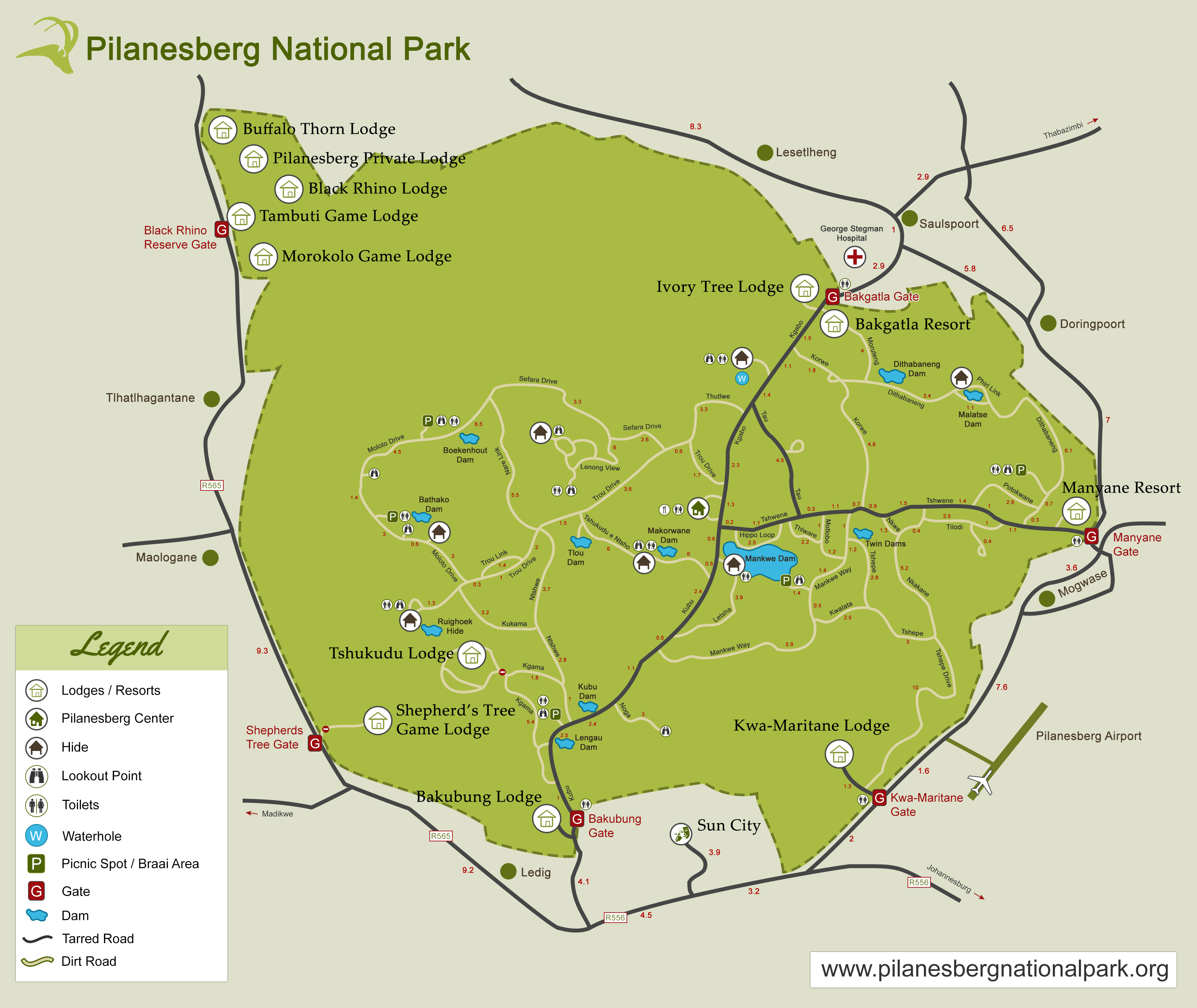
After about an hour or so, we reached the Bakubung gate of Pilanesberg National Park. Now for those – like me a few months ago – who don’t know exactly how these South African (and probably most other places in Africa as well) parks are set up, they are just like a huuuuge zoo, except that there is no supervision and no care for the animals. They are as wild as they get. However, like a humongous zoo, the park is fenced all around, so the animals cannot arbitrarily get out and encroach into human civilization. Does that never happen? Of course not – I read in The Elephant Whisperer that, for instance, elephants sometimes breach the fence and escape out of the park. Does it happen all the time. Most likely not. You just need to be aware that once in a while this could happen. That said, I still don’t get the nuanced differences between a National Park, a game reserve, etc. (I believe there are a couple more designations).

Like all other parks, Pilanesburg has a few gates – we went in from one of the Southern gates, the Bakubung gate. The gate to the immediate west of this one is the Sun City gate. Sun City is a pretty big resort empire right at the outskirts of Pilanesberg National Park. Had we had more time, our host said that we could have visited it. We were not too worried about not visiting it 🙂

Our host informed us that Bakubung means Hippopotamus. Wiki informs us that Bakubung stands for “People of the Hippo” – I don’t know who is (more) correct! Thankfully, there were no Hippos waiting at the gate; by all accounts, Hippos are the single most dangerous animal in Africa. Though they are mostly vegetarians, they are very territorial and cannot stand anyone encroaching their area (though I later got a photo of a dude … as I was across the fence from him).

Right outside Bakubung gate, instead of Hippos, there were a few shops selling curios and souvenirs. As our host went to purchase our tickets, we checked out the souvenirs and decided to purchase some. In retrospect, though it meant that we carted our precious items all across South Africa and in Zimbabwe, it was a good decision because we did not really have time to make similar purchases later on in our travel. [[i]needless to say, we could always have made time for it if we hadn’t already procured them]

Then, it was time for us to get going.

The first animal we saw was an elephant

The first animal we saw was an elephant

Look, if you don’t see one in the photo, that makes two of us ;-). I didn’t see the elephant either but as everyone else in the vehicle saw one, I pointed my camera in that general direction and clicked. If you don’t see it, I’m with you!!

Then we came across this herd of ... kudu (?)

Then we came across this herd of … kudu (?)

Now, I am a sedentary office worker. At most I can promise you I won’t mistake a giraffe for a zebra or a hippo for a rhino. But the buck (pardon the multi-level pun) stops there. The best I can tell is – deer. You guys figure out whether it is a pronghorn, antelope, gazelle, kudu, bushbuck, and what have you. As for birds, I will be honest. I’ll just say “bird” – vulture, peacock, I can figure out. And we saw neither in South Africa. So, you’ll see photos of a few … birds!! Ostrich I can – and did – identify as well. They show up a few posts later though, not in Pilanesberg.

PS: I liked this photo because of the thousands of points of light 🙂

A zebra

A zebra

We were probably at Lengau Dam

We were probably at Lengau Dam

Looking at the map, it appears that this was at Lengau Dam.

Blu Wildebeest I believe

Blu Wildebeest I believe

Rhinoceros

Rhinoceros

An elephant, far away

An elephant, far away

More elephants

More elephants

Rhinos ... in retirement

Rhinos … in retirement

These rhinos were not too far from the road. Pensioners, our host said, as they appeared to be pretty laid back and generally not interested in being mobile. The word was new usage for me – hadn’t heard it in quite a while. Makes sense, as in the USA, pensions are pretty rare. Needless to say, retired folks are referred to as retirees here, not pensioners! Regardless, the usage was quite amusing.

Another view of The Pensioners

Another view of The Pensioners

Roadway sign

Roadway sign

At this point, it was about noon and we decided to have lunch. For lunch, we stopped at a fenced picnic area. In a twist, once inside the National Park, humans need to be fenced in while the animals roam outside. So, we had a couple of minutes of “dare” as we stepped out of the vehicle (host was quite confident that there was no wildlife in the vicinity but still …), and entered the gate into the fenced area, which we then closed behind us. When we complained that there were no locks on the latches, our host said that the animals are not smart enough to undo the gates :-).

And so we ate the little picnic box that our hosts had so thoughtfully packed for us, in keeping with our dietary restrictions (vegetarian). We saw a few birds inside the picnic area. And we were able to use the restroom facilities in there as well.

A bird

A bird

One thing I forgot to mention is that the roads that we drove in were mostly dirt tracks. There are only a couple of through roads that are properly paved. If you go off those roads, it is helpful to have a vehicle with a higher clearance. Not that cars won’t be able to navigate them (though I cannot guarantee that either), but it will be tougher, plus it will be more difficult to look out and observe the wildlife. So, it was definitely a good idea that we had our host give us a tour of the area for the day.

We saw elephants grazing in the distance, and a couple of baby elephants as well

We saw elephants grazing in the distance, and a couple of baby elephants as well

A warthog who, our host informed us, is pretty dangerous with its sharp horns/tusks

A warthog who, our host informed us, is pretty dangerous with its sharp horns/tusks

We next saw some zebras - here with a front pose ...

We next saw some zebras – here with a front pose …

... and a side pose

… and a side pose

Giraffe in the distance

Giraffe in the distance

... not just one!!

… not just one!!

Lots of deer (kudu?)

Lots of deer (kudu?)

Our host informed us that these group of deer have only one male and the rest are female. They are his harem and he protects them and leads them away from danger. I didn’t do research on this – but surely the gender balance is not that skewed in the world of deer. What happens to all the other male deer? Time for some research, I think 🙂

One of the females ...

One of the females …

... and a male

… and a male

I cannot tell if he was the leader of the group or one of the other young loner males that our host showed us – these were in the fringe of the group)

I am so bad with wildlife identification that I cannot even tell if this is the same dude as the one in the previous photo

I am so bad with wildlife identification that I cannot even tell if this is the same dude as the one in the previous photo

Here's ... yup, another bird!!

Here’s … yup, another bird!!

We were driving along on one of the dirt roads when suddenly, we spotted a couple of cars that had stopped just in front of us. We nudged closer and saw an elephant coming towards us. He was all alone but heading straight our way without pausing. Slowly but surely, the cars in front of us started backing off. Our host let them back out past us. This made our vehicle the first line of defense in the humans vs. beast encounter.

We continued backing away, and he continued ambling towards us. Mrs. Porcupyn and Katya were a bit scared, so were Baab and myself (though a bit less so). But our host assured us that the big dude wasn’t giving vibes of threat. He was a young bull, not a grumpy old dude who would’ve been a bit scary. Rather, flapping his ears to a regular beat, he appeared to be pretty calm. The signs of an agitated elephant, per our host, were ears that were immobile and/or a tear or two running down the eyes. Those elephants you especially didn’t want to mess with.

Our guy, on the other hand, was just out for a stroll in the park; though, when he just turned off the road to sniff a tree, our host said that it was not a good idea to drive past him as it would agitate him. Sure enough, the young bull turned right back onto the road. We continued backing away from him. Our host informed us at this point that all the other vehicles had given up and left for other locations.

Presently, our bull came across a dungpile (left by some other elephant). As I went ewww, he dug into it with his trunk. Per our host, elephants sometimes do that and might even consume it (yuck!). At some point along the drive, he also pointed out some thorny bushes and said that elephants snack on those. But the thorns go right through the elephants and come out in the dung. Because these thorns could potentially shred car tires, he said that it was not advisable to drive over elephant dung.

Soon after this, the elephant left the road and headed to one side. By now, we had spent about 15 minutes waiting for the elephant to give way to us. We grabbed our opportunity and continued further. And then were stymied yet again.

The viewing location our host was taking us had a parking area, and then gates to walk in and observe wildlife in and across a lake. However, as we saw, there was a family of elephants in the parking area. Our host said that it was best to wait for them to clear out before we ventured closer, else they could/might smash the vehicle to pulp.

Here are a few photos of the family – as they left the area, we could clearly see one elephant who had stayed behind and was acting agitated. Even to our untrained eyes, we could observe that he was unhappy. His ears had flapped back and were not moving. He was walking back and forth. According to our host, he didn’t appreciate the cars parked in “his territory.” Finally though, he left as well, and we could park and walk through the wooden planks to the viewing area.

img_1148lr img_1157lr img_1166lr

If I figured out correctly, we were at the Mankwe Dam viewing area now. We saw a crocodile lazing in in mud, warthogs grazing in a supplicatory posture – they were on their (front) knees, which is how they usually eat, explained our host. We also spotted a couple of what appeared to be hippos on the other side of the water; at that time, we were unable to tell for sure whether they were animals or two large boulders. Subsequently, after looking at the photos, I can now confirm that they were indeed hippos. Also in plain sight were a few birds – needless to say, I am not taking any questions as to which birds they were (you are welcome to figure it out – photos are below!).

Lazy crocodile

Lazy crocodile

img_1178lr img_1184lr
Birds!!

Birds!!

Hippos indeed!

Hippos indeed!

A bush buck

A bush buck

Zebra at Pilanesberg Centre

Zebra at Pilanesberg Centre

A couple

A couple

These are, I believe, kudu!

These are, I believe, kudu!

Fowl ( I recall our host naming them, but I forget now what he called them)

Fowl ( I recall our host naming them, but I forget now what he called them)

Rhinocerous mom and cub (story coming up ... below)

Rhinocerous mom and cub (story coming up … below)

So, we visited the Pilanesberg Centre next, which is nothing but a small oasis for tourists in the centre of the Park. Our host took us there saying that we might get something to eat, while watching wildlife. He said that there is a salt slab (I forget the specific term he used) that animals come to lick once in a while, while also drinking water from the small lake. Apparently, there are more animals around when the water is scarce (makes sense); and right around the time we were there, there had been enough rains earlier on that there was abundant water elsewhere as well. Besides, per our host, the salt slab (salt lick?) appeared to have been all used up too. So, though we got ourselves some pizza and coke to wash it down with, we didn’t have a lot of success with animals except the bush buck, the zebra and the impala (note that the above photos of the impala, the fowl and the rhinos were taken later). We also ate some pieces of cake that we had brought with us, and got back to the car.

Here too, the cars were parked outside of the fenced location. I am assuming that we had safety in numbers and that the predatory animals (cats mostly) wouldn’t come after us here. As we walked to the car, a few zebra came galloping on the other side of the road from the parking area, crossed the road, and disappeared behind the bushes (to reappear on the other side of the viewing area of Pilanesberg Centre I would guess). While I’ve seen zebra before in zoos (and in Disney’s Animal Kingdom), this was obviously the first time I had seen them completely out in the wild (as with all other wildlife too) – but it was really nice to see them so close to us.

Once we got started again, we were driving towards the Manyane Resort area and were on one of the dirt roads (maybe somewhere near Nkwe), when we came across the Mom and Cub pair. Our host informed us about the differences between the White and the Black Rhino. One has curved lip, the other has straight lip. In one species, the cub goes behind the mother; in the other, the order is reversed. We were excited to see them at close range, and I for one was not really able to properly identify which rhino species these were. Never mind, because minutes later, we noticed that they were not as excited to see humans in the vicinity. One of the other cars driving behind us apparently spooked the cub and he (or she) took off – mom followed close behind cub’s heels. He runned and runned and runned ;-). Soon, we came to the main road and turned right. As we were driving, within a couple of minutes, we caught sight of them – they were far far away. Our host stopped and we observed them – I managed to zoom in and get a decent video of the running pair. They finally slowed down stopped and dawdled around for a minute, then cub took off again, though at a more sedate pace this time, until they finally disappeared behind the bushes.

Though I had originally been more excited to see the elephant herd than the rhinos (the pensioner gang), this was definitely one of the highlights of the day. That and the fact, which I later found out after research, that elephants are a dime a dozen in these parks. Rhinos are the ones who are more threatened and poached for their horns (though I did recently read about a lot of elephants being slaughtered in Botswana, which is reputed to be one of the better countries for wildlife conservation – until I returned from South Africa, I hadn’t realized that Botswana has a better track record of wildlife conservation).

Next we came across a lone (I believe) giraffe – he was right next to the road, feeding on some high vegetation. Our host commented that the tongue of the giraffe is blue in colour and quite dexterous in separating leaves from the branches of the tree. He also said something else about giraffes that I forget; I do remember reading (after we returned from our trip) – but we didn’t see this in action – in a book after I returned that giraffes urine is treacly. The reason for this is for them to conserve water in their bodies (not to myself: search for youtube videos of a urinating giraffe!!). Anyway, without further ado, here are the photos of this loner giraffe. He bestowed a full fronty upon me. Isn’t he handsome? [OK, he might be a she – I didn’t really check properly!]

Giraffe side view

Giraffe side view

Giraffe front view

Giraffe front view

Next, we reached the gate of the park. Right next to the gate is (obviously) the fence, and just inside the fence was the Master of His Universe, Sir Hippopotamus! As he lay firmly in the water, it was difficult not to laugh at the dude. His swimming pool was just about enough for him. And he looked on as if to say, “You puny human! Don’t you dare laugh at me!” Thankfully, he did not try to test the strength of the fence!!

Master of his own domain

Master of his own domain

I missed mentioning a group of hippos that we saw.

Group of hippos, dead to the world

Group of hippos, dead to the world

Scary hippo - any dentists around? ;-)

Scary hippo – any dentists around? 😉

This point I am a bit confused about. I don’t recall if Manyane Resort was within the gates of the park or just outside. But anyway, we did visit this area as well. A most funny incident happened – there were a few deer and monkeys in this area, as well as other humans – as we parked the vehicle and started walking toward the swimming pool there. I was talking with our host while the rest of the family was a couple of steps behind. Suddenly I heard someone behind say something (not from our group) in alarm. I turned around just in time to see a deer leap across in front of Mrs. Porcupyn. Let me qualify that. It leapt over and above Mrs. Porcupyn’s height. So, I would guess that the leap took the deer at least over six feet in height. Unfortunately and needless to say, I had absolutely no time to get my camera out and in position!! I was very amused. Mrs. Porcupyn, not that much!

We left Manyane resort area, and our host still had a trick up his sleeve. We got onto the main road near Mogwase, and proceeded west passing the Pilanesberg Airport. Our host then took us to a hide in the Kwa Maritane Resort which is just east of the Sun City resort area. He knew some folks in Kwa Maritane and got to park inside the resort, and showed us the way to a hide. This is right next to a small pool of water, and – he informed us – is a good area to see animals up close.

Our host stayed upstairs in the restaurant area, while we went through the tunnel to get to the hide, which is a camouflaged (at least to humans – you bet the animals know they’re being watched!) viewing area. When we went there, there were no animals. So we were a bit disappointed. But there were other humans lying in wait like us. After spending about 15 minutes – which is what our host had said we had time for – we started walking back. At this point, we were met by our host inside the tunnel and he was excitedly saying that he had spotted a herd of elephants walking toward the hide area. So back we went and waited some more.

Sure enough, we could hear some sound coming from the elephants but we had no clue how close or far they were. Huge they might be, but those elephants are very stealthy in the jungle. After some time, we spotted the elephants but they were behind the bushes and trees and they appeared to be heading away from us. We suspected that something might have alarmed them and so they decided to give the watering hole a pass.

So, back we went reluctantly. We had hardly taken a few steps when some of the others (still) watching came after us and said “They are coming! They are coming!” We turned around again, taking care not to make too much noise.

And this time, we got to see two elephants come to the pond and drink water quite noisily. It was fun to see them up close, though the light at this time had started failing, so the photos are not that clear.

Elephant drinking water

Elephant drinking water

Another view

Another view

With that last impression of Pilanesberg, we finally turned around and headed home to Rustenburg.

Later that evening, we ordered take out from an Indian food place that was close by. Our host patiently waited the 30 minutes it took for the food to be ready (we also needed directions to get to the place because the original location that our host knew about had closed). After eating the food, we know now why that first location closed (assuming they are the same owners)!! We had asked for moderately spicy food, in deference to our hosts who weren’t used to a regular diet of Indian food; however, when we got the food home, I – who has the spiciest (and sweetest) tongue in the family – was needing multiple sheets of tissue paper to wipe my eyes (and other parts of the face). Other than the spiciness, the food was all right.

Safari experience
– getting ready
– filling petrol
– drive to Pilanesberg National Park
– Royal Bafokeng
– Baphutatswana
– Bakubung Gate
– Purchases
– Picnic area
– Dirt roads unsuitable for cars
– First elephant sighting
– Tour buses and zebras at the dam
– Rhino pensioners
– Good areas around the park to spot wildlife
– Kruger vs Pilanesberg why we chose the latter
– Platinum prices
– Rhino mom and calf
– Elephant herd
– Crocodile sunning himself
– Visiting the Hide
– Dinner from Indian place

July 25, 2018

South Africa Trip – Travel (MCO-JFK-DOH-JNB) and Day One

Filed under: Family,Geography,Humour,Travel — Porcupyn @ 8:44 am

All that brought us back to Day 0. Our flight, that had been scheduled for 6:15 am or so (if I remember right) at the time we purchased our tickets, had been changed to 6:45 am by JetBlue scheduling. As a result, our two hour transfer time in JFK had been reduced to just about an hour and a half. Baab had warned us that in JFK, in order to change to our departure gate, we would need to get out of our arrival terminal and go through security once more then find our gate. By the time the morning dawned, like I said, I was in a bit of panic just in case our MCO-JFK flight was axed. Fortunately, we were able to get to the airport by about 3:30 am and check in – the flight was supposedly on time.

By the time we reached the gate though, we were informed that there was a 30 minute delay. We managed to all board very quickly and by the time the flight took off, it was only about 20 minutes late. So, though we had over an hour in JFK to get to our gate, we knew we still had to hurry!

There were clouds in the sky as we took off from Orlando – I had been half afraid that we might get delayed once more because of six am thunderstorms!! But we made it to JFK without any incident. It had been a while since we last flew into JFK and I didn’t recollect any of the scenery that I could see this time. Not sure what flight path the captain took. Here are a few sample photos:

Enjoyed the geography of the area from the air

Enjoyed the geography of the area from the air

Lot of little meandering rivers

Lot of little meandering rivers

Lot of little meandering rivers

Lot of little meandering rivers

Coastline off Long Island

Coastline off Long Island

Coastline off Long Island

Coastline off Long Island

Flying over Long Island approaching JFK

Flying over Long Island approaching JFK

I did not get to see any part of Manhattan on the whole approach – we probably turned east way before New York.

We are all window seat lovers :-). So, usually, our configuration – if we can get it – is Mrs. Porcupyn and Katya sitting window and next to window, Baab and me in the windows behind – essentially, we occupy three different rows on the plane. We love looking out the windows for sure. For the MCO-JFK leg, once Baab found out that the schedules had changed and we were leaving MCO later than originally planned, he managed to move the three of them further forward. I like staying in the back and bet on myself being able to catch up once we were out in the open terminal 🙂

The plane took nearly half an hour to taxi and get to the gate (thank you JFK!!). Now I was getting close to hitting the panic button. But I stayed calm, and managed to catch up with the rest of the family by the time they reached the inter-terminal shuttle. We got on the shuttle, got off at the terminal, breezed through security thankfully (MCO would have probably taken at least 45 minutes; we are used to MCO and so I was shocked to learn from my Bay Area friends that SFO security typically clears in less than 15 minutes) … and – boarding cards in hand – landed up at the gate and were among the last folks in the queue to board. Yes, our flight was almost all boarded when we got there. At that point, Roadblock!!

Apparently, the boarding passes given by JetBlue in MCO – all the way through to JNB – were no good. We had to get over to a different line (which was empty at this point!) to get fresh boarding passes from Qatar Airlines staff. As we were the only ones in the queue, I thought it would be a quick thing – but it wasn’t! Three weeks before departure, Baab had informed us that even if both parents were travelling with minors, South Africa requires birth certificates that display the names of the parents (what a dumb rule, I thought, and why hadn’t I been told about it sometime during the ticket purchase process). After double checking with another family that had recently returned from South Africa, I realized that the rule was very valid and after further thinking, I realized that the rule actually makes sense. Now, the Qatar Airlines staff did ask us to furnish the birth certificates – as I had them stuck deep inside my carryon bag, this took a couple of extra minutes.

But finally, we were ready to board, fresh boarding passes in hand. We were now literally the last to board the plane as all of those few folks who were behind us in the queue had now managed to board. South Africa, here we come!!

Here are some photos of the JFK-DOH leg (photo credit: Baab).

Interior of the plane

Interior of the plane

Vegetarian Meal 1

Vegetarian Meal 1

Vegetarian Meal 2

Vegetarian Meal 2

Control Tower, Doha

Control Tower, Doha

Inside Doha Terminal

Inside Doha Terminal

Need to go through passport control

Need to go through passport control

Airport shops

Airport shops

Transiting from Qatar Airways to Qatar Airways would be a breeze, we thought, so we were not unduly worried that our flight took a few minutes to get to the gate (nowhere close to how much time it had taken for JetBlue at JFK); once in the terminal, I saw that we had to go to Terminal E (I might have gotten these letters wrong but anyway) and we were in Terminal B. I saw a shuttle that was on a higher level than where we were. So, we went up the escalator and got in the shuttle. It went to Terminal C (or so I thought I heard the announcer say – I was too busy taking a video of the shuttle). We waited inside the shuttle for it to go forward even as I – from the corner of my eye – saw most passengers getting off and I also caught a security guy outside yelling something. Next thing I know, he’s literally facepalming, the doors close, and the shuttle reverses.

Uh oh! Now we know what’s going on – the shuttle is a very short one, and we didn’t even need to get on it. We could’ve just walked. Anyway, now that we’d wasted enough time, we decided to stay on yo-yo right back to the other station. I see the security dude again, and we each laughed! From here, it was just a short walk down the stairs and around some shops to get to our gate even though it was deceptively described as a whole different terminal. Guess what, this flight was about to board as well, so we quickly got in the line.

The problem with taking oodles of photos is that it is very very difficult to pick and choose from them. The problem is compounded when you make two trips within a couple of weeks of each other (especially when you don’t travel that often) and don’t even have time to go through all the nearly 5,000 photos and videos that you and your family have taken. So, these photos that I share might (or might not) be the pick of the lot, but will still provide a representative sampling of our trip. You’ve been warned! 🙂

Once the flight got off the ground sometime around 7 am (JNB ETA was 3:40 pm), I was looking forward to what would be a nice flight through Africa and that I might even get to see Kili from the air. As we would be flying almost due south (first time ever that I had been on a nearly north-south flight along more or less the same time zone throughout), there would be no jet lag at all.

Guess again, buddy! The flight took off north of the airport and turned northeast. With me sitting on the right side of the plane, I bore the brunt of the sun’s rays. Each minute, I was expectantly looking forward for the flight to make a sharp turn towards the southwest; didn’t happen. The plane did take a more easterly orientation, but all I could see was a lot of water below, and desert far to my right. The scenery couldn’t have been more boring. After a while, it was obvious to me that we were not going to be heading south over land. And I was right; we kept going over the seas past the Arab peninsula then headed south.

Even though I had heard and read about the spat between Qatar and the other Gulf states, I hadn’t considered that the other countries would be spiteful enough to not let Qatar Airlines flights over their airspace, but that’s obviously what was happening (as I later deduced). While in flight, I kept thinking that maybe it is some Great Circle Route that I had not realized. Unfortunately, what that meant was that the window seat was not going to be an advantage for the next few hours for sure. I sat back, relaxed and turned my attention to the entertainment options.

After a few hours (just past noon local time, to be precise), I was looking at our progress on the map and realized that we were finally nearing the African coastline and would likely enter the continent. Sure enough, we passed over the island of Zanzibar.

Fumba (centre of the photo) and Kwale Island (bottom left corner)

Fumba (centre of the photo) and Kwale Island (bottom left corner)

Zoomed into Fumba, Zanzibar, Tanzania

Zoomed into Fumba, Zanzibar, Tanzania

Until we passed Lake Malawi, we had mostly cloudy skies like this one

Until we passed Lake Malawi, we had mostly cloudy skies like this one

But then, it got better and I was able to get photos of rivers with and without water, mountains, valleys, lakes (per my interpretation of course), and really weird land shapes, especially as we got closer to Johannesburg.

img_0895lr img_0896lr img_0903lr img_0912lr img_0920lr img_0929lr img_0931lr img_0933lr img_0936lr img_0939lr img_0944vlr img_0946lr img_0951lr img_0954lr img_0956lr
Finally, we are in South Africa :-)

Finally, we are in South Africa 🙂

Not the most encouraging of signs to see as soon as you land in a new country!

Not the most encouraging of signs to see as soon as you land in a new country!

Once we got out of the plane, the immigration and customs formalities were very quick – and yes, we did need to furnish the birth certificates upon arrival. Fortunately, I got WiFi in the airport rightaway, so while we were waiting for our bag (we had only one check in bag and one carry on apiece), I was able to contact our host and inform her of our arrival. She replied immediately and said that she was waiting right outside for us.

So, within minutes of receiving our bag (with one wheel – of two – missing!!), we were walking out of the airport across to the parking lot. After getting our bags stowed in the trunk, we were ready to ride out into the sunset … and beyond – to Rustenburg. Though I was not too tired, I was very thankful that our host was picking us up as that left me free to ask questions about the country and the area, as well as take photos of the traffic – and the sunset of course!

Hadn't realized that the freeway would be this wide!!

Hadn’t realized that the freeway would be this wide!!

Same area different view - love the way the sunlight shines off the earth

Same area different view – love the way the sunlight shines off the earth

Interesting roadway signage

Interesting roadway signage

Nice way to illustrate toll roads

Nice way to illustrate toll roads

Like some of the other old British colonies, South Africa drives on the left

Like some of the other old British colonies, South Africa drives on the left

A few sunset photos now - nature photos are always my favourite!

A few sunset photos now – nature photos are always my favourite!

A few sunset photos now - nature photos are always my favourite!

A few sunset photos now – nature photos are always my favourite!

Getting close to Rustenburg now

Getting close to Rustenburg now

A large toll plaza

A large toll plaza

img_0993lr

Between Pretoria and Rustenburg (that’s what I think our host said), slower drivers tend to drive off the road into the shoulder if a faster vehicle is approaching from the rear. She said that usually at night she doesn’t follow this rule of thumb. But she said that this does not happen most other places in South Africa (again, this is my recollection of what she said – I am pretty sure I saw this behaviour all over the place, and I followed it as well).

Next Page »

Create a free website or blog at WordPress.com.